IPhone LogoIPad LogoLight Logo
  • Home
  • Blog
  • About
  • Contact
Central America Guatemala
by flightlesskiwi

Quetzal country

15th February 2017
1
0
Share

There were two options to renew our soon-to-expire Guatemalan visas.

  1. Apply for quick and easy visa extension in Guatemala city
  2. Make a border run to Belize or Mexico

Guatemala City is located an easy one-hour’s drive from where we were staying in Antigua. Option one. Clearly too simple.

A cross-country, multi-day road trip to Belize sounded like more fun. A lot more fun. Option two it is!

This was the second time that expiring tourist visas had led to a detour to this small Central American nation.

After our previous cross-Guatemala drive had us winding slowly through mountainous back roads. We decided to follow the recommended route across Guatemala.

This took us through quetzal country.

If you are anything like me,  you probably don’t know what ‘quetzal country’ entails. Perhaps it conjures up ideas of travelling through the wild jungle. Vast green expanses filled with mysterious jabberwock-esque creatures.

Jabberwocky
Artist’s rendition of a quetzal in its natural habitat

As it happens, quetzals don’t look exactly like this.

Perhaps you are not as uninformed as I was about quetzals. Maybe you are a keen ornithologist. Just in case you aren’t one, here’s the lowdown:

Aside from being the name of Guatemala’s currency—it is also the national bird. Like what the kiwi is to New Zealand.

Except quetzals can fly. They are brightly coloured. The males even have long, elaborate tail plumage. Quetzals are a lot more glamorous than New Zealand’s stumpy, flightless, pointy-beaked chicken.

A kiwi and a quetzal. The kiwi is the chubby chicken. The quetzal the elegant parrot.

To give us the best chance of seeing one, we splashed out on a room at a fancy eco-lodge.

The sacrifices you have to make to be an intrepid explorer.

In typical Flightless Kiwis style, we celebrated our arrival at a fancy eco-lodge by immediately locking ourselves out of the room. With the hotel’s only copy of the key firmly sealed inside.

See also  If at first you don't succeed

Luckily, Ben managed to remove a section of the loosely fitted window frame. This made enough space to post Emma through a narrow-spider-filled gap.

The concerned staff soon returned with assorted tools for breaking and entering. By this stage, Ben was deftly re-fitting the window frame and Emma was dusting the last of the spiders out of her hair. Possible new career option? I suspect ‘jewel thief’ would look questionable on the resumé, but could lead to future travel.

The quest for quetzals began the next day at a quarter to early o’clock.  We explored the surrounding cloud forest in the morning mist. Peering hopefully into the dense foliage.

Despite being brightly coloured with elaborate tails, quetzals are surprisingly tricky to spot.

img_2297

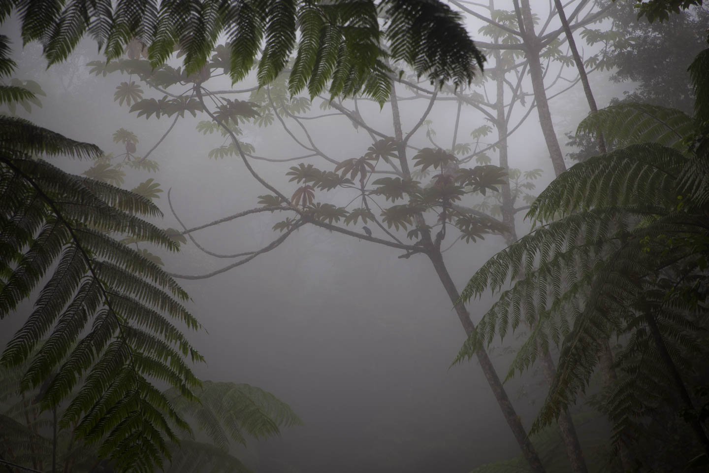
Nope. No quetzals here, but the forest is pretty in the morning mist.

In the dim morning light, quetzals are even harder to photograph than they are to spot.

We somewhat failed on the quetzal photographing front. But here are some wobbly, blurry images so that you can get an idea of what the critter looks like.

And here’s some shots from Getty Images. Taken by people who did a much better job of photographing quetzals than we did.

Embed from Getty Images


Embed from Getty Images

We had survived our foray into the wilds of Quetzal country. However, we also reached the realisation that bird-spotting is not our forte. Time to return to the 4Runner and continue our cross-country odyssey.

pb260584
birdbird spottingbridgedrivingecolodgeGuatemalanaturequetzalroad blockroadswildlifework
Related Posts

And try again

14th June 2017
7
0

A little over a week after our first miserable failure. We were back, climbing Volcán Acatenango… again.

(more…)
See also  Heading south again—for a change

Not quite Guatemala—Part 1

24th September 2016
0
0

There was one time, way back in Belize when we were very nearly in Guatemala.

Top notch security on the Guatemalan border. It sure keeps out those pesky tourists.

Location: El Pilar ruins, Belize. Distance to Guatemala: 615.18 m (2018.32 ft)

But ultimately we decided not to go, and returned to Mexico instead.

We then of course faffed about for quite some time in Mexico. So long in fact that many of the friends we thought we would see again in Guatemala were, by this time, in Costa Rica, Panama, and even South America. Whoops.

The rumour going around was that we were going to apply for Mexican citizenship. The thought did cross our minds. We love Mexico. But seriously. It was time to burn some rubber and leave Mexico in our dust. Sort of.

Maybe after a detour around the Mexico/Guatemala border.

From San Cristóbal, it would have been possible to drive directly to the La Mesilla border crossing and be in Guatemala the same day. It would have been a 175 km (108 mi) drive. We could have breakfasted in Mexico and enjoyed dinner in Guatemala.

Nope. Too easy.
Nope. Too easy.

Instead we opted for the smaller, quieter border crossing at El Ceibo. Which meant we might as well drive back through Palenque. The road between San Cristóbal and Palenque is famous for road blocks. But it sounded like the protesters would open the road each day in the mid afternoon if you waited patiently, so even with the delay, the 219 km (136 mi) journey to Palenque sounded pretty manageable.

Too straightforward.

Instead, we opted for an elaborate detour around the Mexico/Guatemala border with time to partake in some sightseeing en route. No rush… right?

Just right.
Just right.

Location: San Cristóbal de Las Casas. Distance to Guatemala: (as the crow flies) 121.58 km (75.54 mi)

IMG_9409

First stop, a rock arch in a nature reserve just out of San Cristóbal.

See also  The journey begins

Location: El Arcotete. Distance to Guatemala: 120.15 km (74.66 mi)

We don’t want to drive too far in one go, now do we?

Next up. A recreation park featuring some caves, just down the road.

Location: Rancho Nuevo caves. Distance to Guatemala: 112.62 km (69.98 mi)

Time to make some serious progress towards Guatemala… oh look—a waterfall!

Location: Cascadas El Chiflón. Distance to Guatemala: 56.76 km (35.27 mi)

img_9590

Now we’re seriously closing in on the border.

Location: Lagunas de Montebello. Distance to Guatemala: 3.82 km (2.38 mi)

The weather was a bit bleak when we first arrived at Lagunas de Montebello

If we camp really close to the border, does that count as visiting Guatemala?

Location: Lago Tziscao. Distance to Guatemala: 1.02 km (3,332 feet)

Either way it’s a great spot to watch sunrise.

img_9693-pano-edit

(You can see a larger panorama in more detail in our full screen panorama gallery)

Then there was that time we did go to Guatemala, but didn’t get our passports stamped.

Location: Lago internacional. Distance to Guatemala: 0km

From there we can only drive further from the border… or go back and get our passports stamped. We of course, drove further from the border.

At first, only a short distance to take a look at Lago Pojoj.

Location: Lago Pojoj. Distance to Guatemala: 3.19 km (1.98 mi)

You can see this panorama a bit larger in our gallery as well.

img_9751-pano

Then we drove a bit further away.

Location: Las Nubes. Distance to Guatemala: 13.86 km (8.61 mi)

Our favourite thing about this spot? The nice peaceful swimming hole located just at the top of this set of churning, crushing falls that eventually disappear into a rocky gorge and emerge hundreds of metres below in a valley. Way to make health and safety very much optional Mexico.

See also  If at first you don't succeed

Anyway. Onward and… further again from Guatemala. We wanted to explore the jungle, but were too cheap to pay for the boat trip. So we looked at the captive Scarlet Macaws and played about on the grounds of the luxury eco hotel that we were equally to cheap to stay at.

Location: Las Guacamayas. Distance to Guatemala: 20.09 km (12.49 mi)

The next stop on our itinerary tiki-touring around the Mexico-Guatemala border was the mysterious Yaxchilan ruins.

But, since we took such a long detour on route to Guatemala, it is probably best if you read about that in our second instalment of ‘Not quite in Guatemala’. Stay tuned…

1 Comment
    karie says: Reply
    February 16th 2017, 6:45 pm

    Still loving it…..keep on posting!

Leave a Reply to karie Cancel reply

Your email address will not be published. Required fields are marked *

Newsletter Signup

Categories

  • Australia
  • Beer
  • Belize
  • Bolivia
  • Budgeting
  • Canada
  • Central America
  • Cook Islands
  • Cuba
  • CVT tent
  • Digital Nomad
  • Ecuador
  • Featured
  • Gear Reviews
  • Guatemala
  • Hiking
  • Humour
  • Kaylee
  • Mexico
  • New Zealand
  • North America
  • Oxfam Trailwalker
  • Peru
  • Photo Friday
  • Planning
  • Smoke Chaser
  • South America
  • South East Asia
  • Statistics
  • Travel
  • Uncategorized
  • United States
  • Upgrades
  • Vehicle
  • Video
Patchwork Antiguaby flightlesskiwi / November 26, 2016
Career changeby flightlesskiwi / February 20, 2017

Stay In Touch

Subscribe for the latest updates.

Instagram

© 2020 FlightlessKiwis . All rights reserved.

  • Home
  • About
  • Blog
  • Contact
  • Privacy

Recent Posts

  • Digital nomads
    by flightlesskiwi / 21st April 2015
  • On the road to ruin (s)
    by flightlesskiwi / 12th October 2015
  • Why we left too soon for the April Sun in Cuba
    by flightlesskiwi / 3rd September 2015

Looking four our old blog?

We’ve archived our stories and photos from our three year road trip from Deadhorse, Alaska, USA to Ushuaia, Tierra del Fuego Argentina here:

PANAM BLOG

Smoke Chaser logo
Flightless Kiwis logo