IPhone LogoIPad LogoLight Logo
  • Home
  • Blog
  • About
  • Contact
North America United States Vehicle
by flightlesskiwi

Colorado is closed. Part 1.

25th January 2015
1
0
Share

Having spent far too long faffing about in Utah and Nevada our time in Colorado was short. (That was about the only thing that was short in Colorado—everything else appeared to be of record-breaking height.)

After visiting Dinosaur National Monument on the Utah side, we had been considering driving to Echo Park on the Colorado side of the park—but we were told that the road was closed. No surprise there, that had happened a lot lately.

So we settled in for a night camping at Green River, still in Utah. Turns out that we wouldn’t have been driving any back roads the next day, even if they had been open. Ben had decided to take the opportunity to change the brake pads while we were stopped there.

However, he somehow managed to cross-thread one wheel stud and shear off another—oops! Two out of six were no longer doing their job.

We felt that having wheels that were actually attached firmly to our vehicle was going to be a plus. This led to the decision to stick to the main highways until we could re-attach them more effectively.

We stopped in the town of Craig and asked at the local Big O Tires whether they could repair them. “Nope, not until Monday, we close in a couple of hours—that job is going to take much longer than that.”

Not what we wanted to hear. Instead we popped into the auto parts store next door, Ben bought the parts he needed and we hit the road…carefully.

The map showed large numbers of National Forest camp sites along the road we were following. We felt certain we would find a good place to stop just off the main highway, without having to take our limping vehicle anywhere too rugged.

What we hadn’t factored in was that Colorado was closed.

Colorado is shut

Every campground we drove past was closed for the season.

It was getting later and colder and we were driving further and further than we had intended. It was looking more and more like we would have to drive all the way to Fort Collins before we found anything open. We weren’t keen to head down any rough side roads with our wibbly-wobbly wheel. Every rest-stop and respectable side road was barred by locked gates, it was beginning to appear that the best camping option was to park on a shoulder of the busy highway.

See also  Let there be LED light!

Just as we were about to give up, we came across a small campground, that was actually open! (Albeit only for another few days according to the sign.) It turned out that camping there was pretty close to just parking on a shoulder of the busy highway, but it did come with a loo, a nice flat area to park and some degree of shelter from the passing cars and trucks, so we called it a win.

We made this magical find just as the sun was setting. So we put all vehicle repairs off until the morning and set up camp.

Feeling that four out of six was not a good number of wheel nuts to have holding such a necessary part of a 4WD on (see, it is even in the name!) Ben set to replacing the offending parts over breakfast.

So much for two hours work Big O Tires! It took Ben 50 minutes—and that included stopping for his morning coffee. Another lesson in why it is best to do your own repairs.

With wheels firmly attached, our next stop was to pick up a better bike rack in Fort Collins. We had found a swing away one on Craigslist, which finally meant we didn’t need to pack and unpack the bikes every day when we wanted to get into the back of the vehicle. Fancy.

Boring chores out-of-the-way, we made for Rocky Mountain National Park.

Which was conveniently open…well, at least some of the campgrounds were. We nabbed one of the last available sites in the open campground and settled in for a relaxing night’s sleep away from the highway.

See also  Bird-spotting for beginners

Only to be woken shortly after by the bugling racket from rutting elk. Now for those of you who have not heard this, it is one of the most ridiculous noises in the universe. A combination of grunting, hooting and squealing, it sounds like a barnyard in a tornado. Not sure what the lady elks see in it, but it seemed to be working.

A crashing noise in the trees right by the tent alerted us to the arrival of the herd of elk. The large male trumpet-squeal-grunted his way right past the tent, followed by 50 or so of his devoted lady-friends, what a sight to see in the middle of the night, from your own front doorstep.

An even more impressive sight, was the stampeding herd running back past the tent at pace after something had startled them just down the road.

Noisy Elk
This is one of the young male elk. His antlers are not dramatic enough to attract a herd of lady-friends.

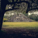
But Rocky Mountain National Park isn’t just about restless night’s sleep in the middle of elk date night. It is also a great place for spectacular mountain scenery (as the park’s name does suggest)

Rocky Mountain National Park
G_5045.jpg

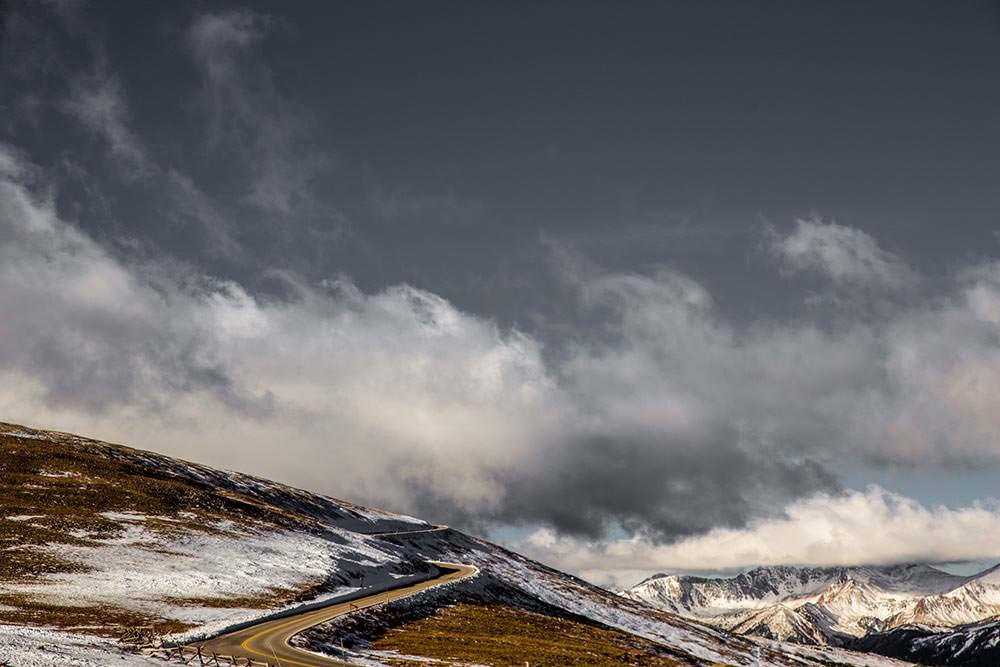
On the conveniently recently re-opened Trail Ridge road we found ourselves driving on top of the world at over 3,700m. (Apparently this is the highest continuous paved road in the United States).

Trail Ridge Road Rocky Mountain National Park altitude
Quite a tall road then…

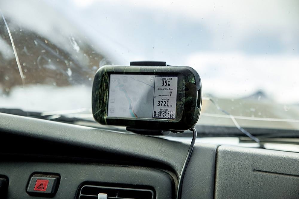
This just gave us a taste for driving to the top of things, it was so much easier (and warmer) than walking.

Rocky Mountain National Park

We had plans to drive to the top of Mount Evans at 4,348m (14,264′). That’s the highest paved road in North America.

After driving for a few hours to get there. We found that it was closed.

Darn.

So we drove a bit further to get to Pike’s Peak (4302m/14115′).

Also closed. (Only 3 minutes before we arrived. But well and truly closed nonetheless.)

This seemed to be a recurring theme throughout Colorado. Roads, campsites, parks, you name it, it had probably closed for the season.

4runner4WDadventurealpinecampingclosedColoradodrivemountainrepairssnowUSAwheels
Related Posts

Loreto

4th April 2015
1
0

Everywhere we travel, we tend to feel at home. Whether it is in the chaotic midst of a big city, alone on a cold windy mountain top, wandering the narrow alleys of a bustling market or lost in dusty back roads, far from the nearest store.

But every now and again, we find somewhere where we can really relax, feel even more at home. Somewhere where we almost completely forget how far away from our actual home we are.

One such place was the town of Loreto, in Baja California Sur.

(more…)
See also  Bird-spotting for beginners

Not quite Guatemala—Part 1

24th September 2016
0
0

There was one time, way back in Belize when we were very nearly in Guatemala.

Top notch security on the Guatemalan border. It sure keeps out those pesky tourists.

Location: El Pilar ruins, Belize. Distance to Guatemala: 615.18 m (2018.32 ft)

But ultimately we decided not to go, and returned to Mexico instead.

We then of course faffed about for quite some time in Mexico. So long in fact that many of the friends we thought we would see again in Guatemala were, by this time, in Costa Rica, Panama, and even South America. Whoops.

The rumour going around was that we were going to apply for Mexican citizenship. The thought did cross our minds. We love Mexico. But seriously. It was time to burn some rubber and leave Mexico in our dust. Sort of.

Maybe after a detour around the Mexico/Guatemala border.

From San Cristóbal, it would have been possible to drive directly to the La Mesilla border crossing and be in Guatemala the same day. It would have been a 175 km (108 mi) drive. We could have breakfasted in Mexico and enjoyed dinner in Guatemala.

Nope. Too easy.
Nope. Too easy.

Instead we opted for the smaller, quieter border crossing at El Ceibo. Which meant we might as well drive back through Palenque. The road between San Cristóbal and Palenque is famous for road blocks. But it sounded like the protesters would open the road each day in the mid afternoon if you waited patiently, so even with the delay, the 219 km (136 mi) journey to Palenque sounded pretty manageable.

Too straightforward.

Instead, we opted for an elaborate detour around the Mexico/Guatemala border with time to partake in some sightseeing en route. No rush… right?

Just right.
Just right.

Location: San Cristóbal de Las Casas. Distance to Guatemala: (as the crow flies) 121.58 km (75.54 mi)

IMG_9409

First stop, a rock arch in a nature reserve just out of San Cristóbal.

See also  Twins from a parallel universe

Location: El Arcotete. Distance to Guatemala: 120.15 km (74.66 mi)

We don’t want to drive too far in one go, now do we?

Next up. A recreation park featuring some caves, just down the road.

Location: Rancho Nuevo caves. Distance to Guatemala: 112.62 km (69.98 mi)

Time to make some serious progress towards Guatemala… oh look—a waterfall!

Location: Cascadas El Chiflón. Distance to Guatemala: 56.76 km (35.27 mi)

img_9590

Now we’re seriously closing in on the border.

Location: Lagunas de Montebello. Distance to Guatemala: 3.82 km (2.38 mi)

The weather was a bit bleak when we first arrived at Lagunas de Montebello

If we camp really close to the border, does that count as visiting Guatemala?

Location: Lago Tziscao. Distance to Guatemala: 1.02 km (3,332 feet)

Either way it’s a great spot to watch sunrise.

img_9693-pano-edit

(You can see a larger panorama in more detail in our full screen panorama gallery)

Then there was that time we did go to Guatemala, but didn’t get our passports stamped.

Location: Lago internacional. Distance to Guatemala: 0km

From there we can only drive further from the border… or go back and get our passports stamped. We of course, drove further from the border.

At first, only a short distance to take a look at Lago Pojoj.

Location: Lago Pojoj. Distance to Guatemala: 3.19 km (1.98 mi)

You can see this panorama a bit larger in our gallery as well.

img_9751-pano

Then we drove a bit further away.

Location: Las Nubes. Distance to Guatemala: 13.86 km (8.61 mi)

Our favourite thing about this spot? The nice peaceful swimming hole located just at the top of this set of churning, crushing falls that eventually disappear into a rocky gorge and emerge hundreds of metres below in a valley. Way to make health and safety very much optional Mexico.

See also  Rather a long way from home

Anyway. Onward and… further again from Guatemala. We wanted to explore the jungle, but were too cheap to pay for the boat trip. So we looked at the captive Scarlet Macaws and played about on the grounds of the luxury eco hotel that we were equally to cheap to stay at.

Location: Las Guacamayas. Distance to Guatemala: 20.09 km (12.49 mi)

The next stop on our itinerary tiki-touring around the Mexico-Guatemala border was the mysterious Yaxchilan ruins.

But, since we took such a long detour on route to Guatemala, it is probably best if you read about that in our second instalment of ‘Not quite in Guatemala’. Stay tuned…

1 Comment
    Rhonda says: Reply
    January 28th 2015, 7:42 am

    love that part of the US! You guys always get the great campsites, dating elk and all 🙂

Leave a Reply Cancel reply

Your email address will not be published. Required fields are marked *

Newsletter Signup

Categories

  • Australia
  • Beer
  • Belize
  • Bolivia
  • Budgeting
  • Canada
  • Central America
  • Cook Islands
  • Cuba
  • CVT tent
  • Digital Nomad
  • Ecuador
  • Featured
  • Gear Reviews
  • Guatemala
  • Hiking
  • Humour
  • Kaylee
  • Mexico
  • New Zealand
  • North America
  • Oxfam Trailwalker
  • Peru
  • Photo Friday
  • Planning
  • Smoke Chaser
  • South America
  • South East Asia
  • Statistics
  • Travel
  • Uncategorized
  • United States
  • Upgrades
  • Vehicle
  • Video
Utah. Definitely another planet.by flightlesskiwi / January 22, 2015
Colorado is closed. Part 2.by flightlesskiwi / January 28, 2015

Stay In Touch

Subscribe for the latest updates.

Instagram

© 2020 FlightlessKiwis . All rights reserved.

  • Home
  • About
  • Blog
  • Contact
  • Privacy

Recent Posts

  • On the road to ruin (s)
    by flightlesskiwi / 12th October 2015
  • Digital nomads
    by flightlesskiwi / 21st April 2015
  • Why we left too soon for the April Sun in Cuba
    by flightlesskiwi / 3rd September 2015

Looking four our old blog?

We’ve archived our stories and photos from our three year road trip from Deadhorse, Alaska, USA to Ushuaia, Tierra del Fuego Argentina here:

PANAM BLOG

Smoke Chaser logo
Flightless Kiwis logo