IPhone LogoIPad LogoLight Logo
  • Home
  • Blog
  • About
  • Contact
North America United States
by flightlesskiwi

Utah. Possibly another planet. Part 2.

16th January 2015
1
0
Share

Still not convinced that the landscapes of Utah would be more at home on another planet? Take a look at the slot canyons of Grand Staircase—Escalante National Monument.

These are deep, narrow canyons carved into sculptural forms by flood waters as they sweep through the canyons after heavy rainfall.

In our attempt to explore some of these canyons we, yet again, followed the vague instructions of a local, combined with a map of questionable authenticity. Boldly armed with this paucity of information we struck out to explore the slot canyons of the Dry Fork of Coyote Gulch.

Dry fork

Our first stop was a narrow section of Dry Fork which was marked as a separate slot canyon on our map. After wandering around for a bit, we agreed it was impressive, but wanted to explore the more exciting sounding Peek-a-boo slot canyon.

After several failed attempts to find the supposed trail between two points in both canyons, we realised that a) Our map was far from being to any kind of sensible scale and b) We had wandered far further along the canyon than intended.

Defeated, we opted to head back to the easy to find lower entrance to Peek-a-boo slot canyon.

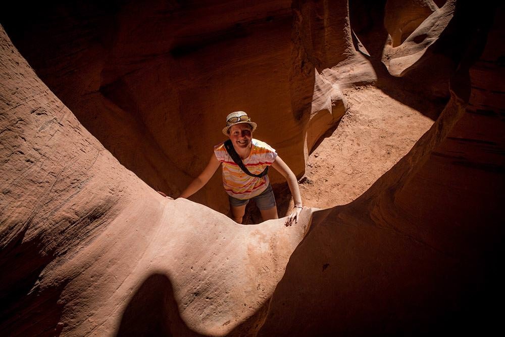
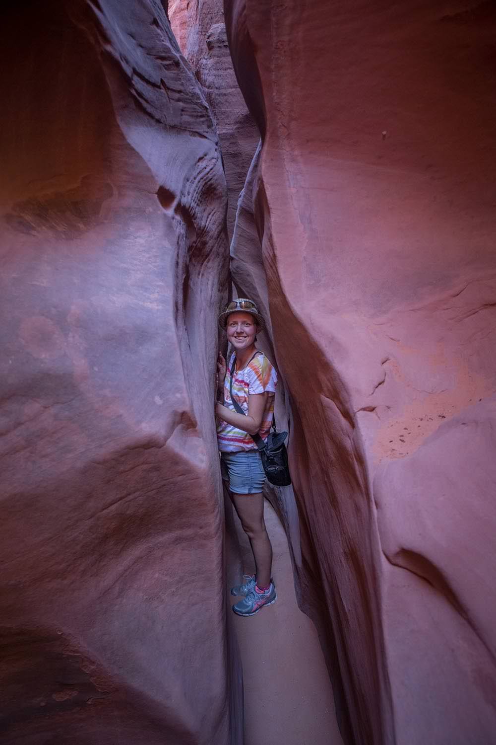
After an undignified scramble up the smooth rock entrance to the canyon, we were greeted with two deep pools of water. Yes, we suppose it had rained a lot lately. A traveller from Germany was just giving up and turning around as we arrived. The general consensus was that no one knew how deep the pools were so didn’t really want to drop into the well-like holes in case they were hard to get out of.

See also  Following the Devil's Backbone

The obvious solution? Send Ben in, he’s tall.

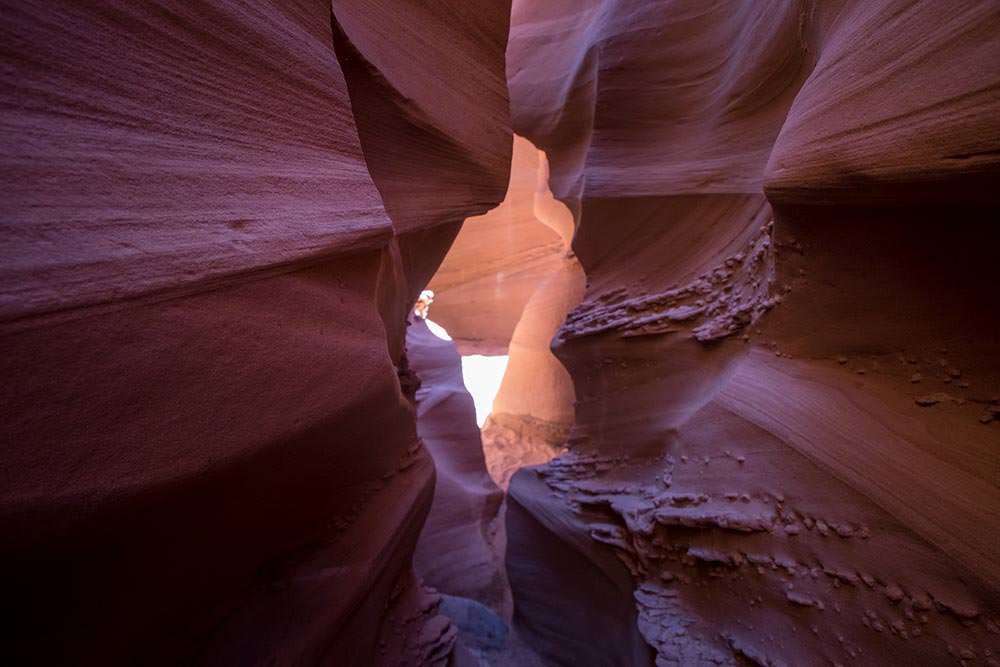
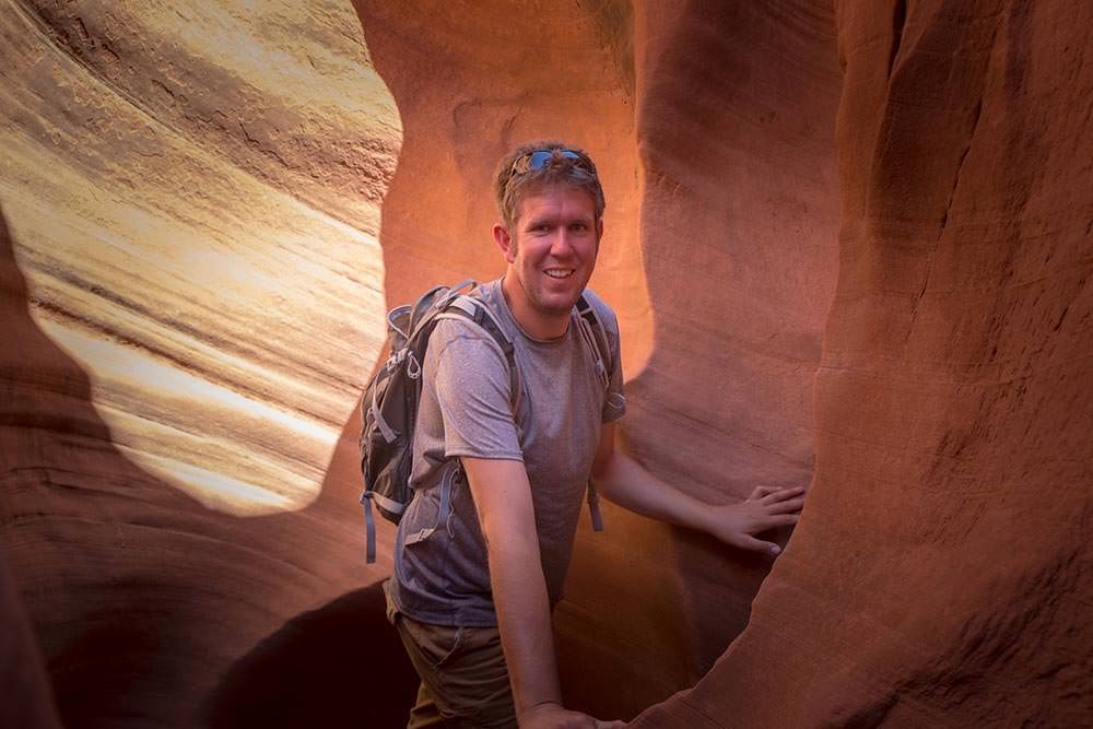
With the water successfully navigated (and Emma’s feet still dry, due to some elaborate jumping and catching manoeuvres) we were free to explore the rest of the canyon. Which was, as advertised, spectacular and a whole lot of fun:

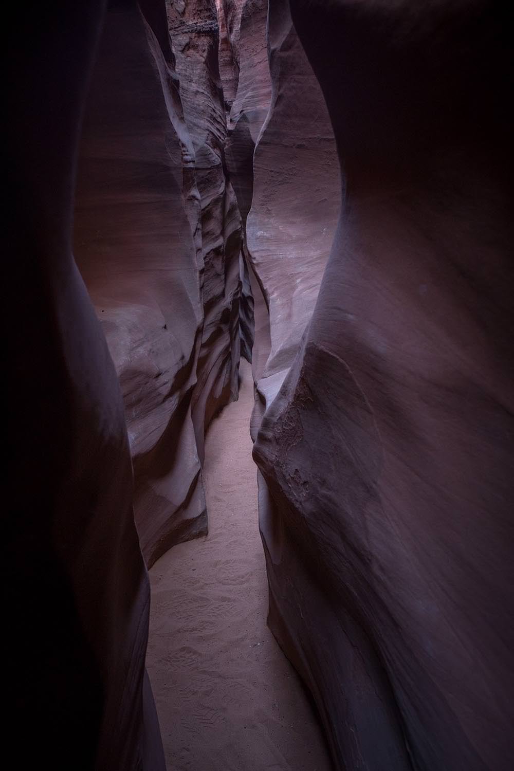
From there we made for the narrow confines of Spooky Canyon for our last slot canyon of the day. Before our water ran out and the hot desert sun chased us back to our vehicle.

Slot Canyon, Escalante—Grand Staircase National Monument
I guess it did look a little spooky.
Slot Canyon, Escalante—Grand Staircase National Monument
But we think a better name would have been. ‘Eat less cake’ Canyon. Because it did get rather narrow.
Slot Canyon, Escalante—Grand Staircase National Monument
Any more pecan sticky buns are out of the question at this point.
Water: Apparently this is a necessity in the desert
Water: Apparently this is a necessity in the desert.

As if a day of squeezing our way through winding sculpted canyons wasn’t enough. We stopped by to check out some dinosaur footprints on the way back to camp:

Dinosaur footprints

You really have to tilt your head and squint to see this one, but this is a row of dinosaur footprints left in mud millions of years ago, which is now exposed rock. Suffice it to say this was followed by several minutes of Emma stomping around pretending to be a dinosaur while Ben watched on looking bewildered. (Fortunately no footage was recorded of this occurrence).

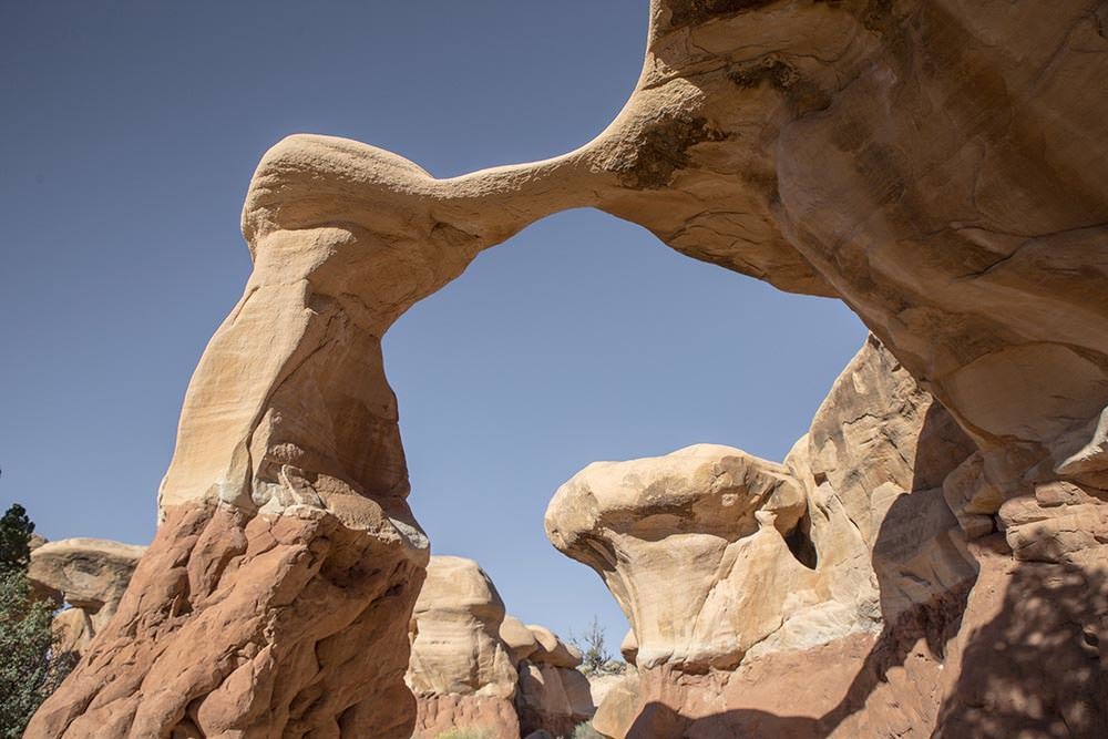
And just in case you still aren’t convinced that Utah is another planet, here are some photos of the Devil’s Garden. Another example of mother nature’s amazing ability as a sculptor. She really could have had a career in that if she had just focused more at art school:

Devil's Garden, Grand Staircase—Escalante National Monument
Metate Arch, Devil's Garden, Grand Staircase—Escalante National Monument
canyonclimbdeserterosionexplorehotNational MonumentrocksSlot CanyonUSAUtah
Related Posts

Following the Devil’s Backbone

18th May 2015
5
0

El Espinazo del Diablo (the Devil’s Backbone—a mountain pass along Mexico’s highway 40) is an infamously sinuous mountain road that joins the towns of Mazatlán, Sinaloa and Durango, Durango. The road has a bit of a reputation for punishing travellers with terrifying accident-inducing winding turns. Luckily travellers are also rewarded with spectacular views as the road runs along a mountain ridge, high in the Sierra Madre mountains.

This seemed like exactly the kind of thing we should investigate further.

(more…)
See also  Washington DC

Not quite Guatemala—Part 1

24th September 2016
0
0

There was one time, way back in Belize when we were very nearly in Guatemala.

Top notch security on the Guatemalan border. It sure keeps out those pesky tourists.

Location: El Pilar ruins, Belize. Distance to Guatemala: 615.18 m (2018.32 ft)

But ultimately we decided not to go, and returned to Mexico instead.

We then of course faffed about for quite some time in Mexico. So long in fact that many of the friends we thought we would see again in Guatemala were, by this time, in Costa Rica, Panama, and even South America. Whoops.

The rumour going around was that we were going to apply for Mexican citizenship. The thought did cross our minds. We love Mexico. But seriously. It was time to burn some rubber and leave Mexico in our dust. Sort of.

Maybe after a detour around the Mexico/Guatemala border.

From San Cristóbal, it would have been possible to drive directly to the La Mesilla border crossing and be in Guatemala the same day. It would have been a 175 km (108 mi) drive. We could have breakfasted in Mexico and enjoyed dinner in Guatemala.

Nope. Too easy.
Nope. Too easy.

Instead we opted for the smaller, quieter border crossing at El Ceibo. Which meant we might as well drive back through Palenque. The road between San Cristóbal and Palenque is famous for road blocks. But it sounded like the protesters would open the road each day in the mid afternoon if you waited patiently, so even with the delay, the 219 km (136 mi) journey to Palenque sounded pretty manageable.

Too straightforward.

Instead, we opted for an elaborate detour around the Mexico/Guatemala border with time to partake in some sightseeing en route. No rush… right?

Just right.
Just right.

Location: San Cristóbal de Las Casas. Distance to Guatemala: (as the crow flies) 121.58 km (75.54 mi)

IMG_9409

First stop, a rock arch in a nature reserve just out of San Cristóbal.

See also  Castle Hill

Location: El Arcotete. Distance to Guatemala: 120.15 km (74.66 mi)

We don’t want to drive too far in one go, now do we?

Next up. A recreation park featuring some caves, just down the road.

Location: Rancho Nuevo caves. Distance to Guatemala: 112.62 km (69.98 mi)

Time to make some serious progress towards Guatemala… oh look—a waterfall!

Location: Cascadas El Chiflón. Distance to Guatemala: 56.76 km (35.27 mi)

img_9590

Now we’re seriously closing in on the border.

Location: Lagunas de Montebello. Distance to Guatemala: 3.82 km (2.38 mi)

The weather was a bit bleak when we first arrived at Lagunas de Montebello

If we camp really close to the border, does that count as visiting Guatemala?

Location: Lago Tziscao. Distance to Guatemala: 1.02 km (3,332 feet)

Either way it’s a great spot to watch sunrise.

img_9693-pano-edit

(You can see a larger panorama in more detail in our full screen panorama gallery)

Then there was that time we did go to Guatemala, but didn’t get our passports stamped.

Location: Lago internacional. Distance to Guatemala: 0km

From there we can only drive further from the border… or go back and get our passports stamped. We of course, drove further from the border.

At first, only a short distance to take a look at Lago Pojoj.

Location: Lago Pojoj. Distance to Guatemala: 3.19 km (1.98 mi)

You can see this panorama a bit larger in our gallery as well.

img_9751-pano

Then we drove a bit further away.

Location: Las Nubes. Distance to Guatemala: 13.86 km (8.61 mi)

Our favourite thing about this spot? The nice peaceful swimming hole located just at the top of this set of churning, crushing falls that eventually disappear into a rocky gorge and emerge hundreds of metres below in a valley. Way to make health and safety very much optional Mexico.

See also  Small town Alaska

Anyway. Onward and… further again from Guatemala. We wanted to explore the jungle, but were too cheap to pay for the boat trip. So we looked at the captive Scarlet Macaws and played about on the grounds of the luxury eco hotel that we were equally to cheap to stay at.

Location: Las Guacamayas. Distance to Guatemala: 20.09 km (12.49 mi)

The next stop on our itinerary tiki-touring around the Mexico-Guatemala border was the mysterious Yaxchilan ruins.

But, since we took such a long detour on route to Guatemala, it is probably best if you read about that in our second instalment of ‘Not quite in Guatemala’. Stay tuned…

1 Comment
    Cs9435866 says: Reply
    January 20th 2015, 3:54 pm

    Found you guys on the 4Runner forum. Will be following your adventures. As I live in Utah and have hiked Spooky, Peek-A-Boo, Kodachrome, Bryce, etc I enjoy following your travels. Safe travels

Leave a Reply Cancel reply

Your email address will not be published. Required fields are marked *

Newsletter Signup

Categories

  • Australia
  • Beer
  • Belize
  • Bolivia
  • Budgeting
  • Canada
  • Central America
  • Cook Islands
  • Cuba
  • CVT tent
  • Digital Nomad
  • Ecuador
  • Featured
  • Gear Reviews
  • Guatemala
  • Hiking
  • Humour
  • Kaylee
  • Mexico
  • New Zealand
  • North America
  • Oxfam Trailwalker
  • Peru
  • Photo Friday
  • Planning
  • Smoke Chaser
  • South America
  • South East Asia
  • Statistics
  • Travel
  • Uncategorized
  • United States
  • Upgrades
  • Vehicle
  • Video
Utah. Possibly another planet. Part 1.by flightlesskiwi / January 13, 2015
Monument Valleyby flightlesskiwi / January 19, 2015

Stay In Touch

Subscribe for the latest updates.

Instagram

© 2020 FlightlessKiwis . All rights reserved.

  • Home
  • About
  • Blog
  • Contact
  • Privacy

Recent Posts

  • Digital nomads
    by flightlesskiwi / 21st April 2015
  • On the road to ruin (s)
    by flightlesskiwi / 12th October 2015
  • Why we left too soon for the April Sun in Cuba
    by flightlesskiwi / 3rd September 2015

Looking four our old blog?

We’ve archived our stories and photos from our three year road trip from Deadhorse, Alaska, USA to Ushuaia, Tierra del Fuego Argentina here:

PANAM BLOG

Smoke Chaser logo
Flightless Kiwis logo