IPhone LogoIPad LogoLight Logo
  • Home
  • Blog
  • About
  • Contact
North America United States
by flightlesskiwi

Bird-spotting for beginners

2nd July 2014
1
0
Share

The town of Homer describes itself as the ‘quaint little drinking village with a fishing problem’. Or at least that is what the bumper stickers at the brewery said.

There is indeed a lot of fishing going on in the area. Everywhere you look someone is offering Halibut Charters. But we weren’t there to fish.

Homer Brewing Company
Homer Brewing Company—better than fishing.

In all honesty, we weren’t really sure why we where there.

We just ended up driving there because the chap we bought our roof top tent off mentioned that we might like it there. In our books, that is as good a reason as any.

There were plenty of interesting galleries, museums and tempting art shops to keep us entertained without needing to go on one of the plentiful halibut charters.

Emma found true happiness in the form of an icing drenched sticky bun that was 80% sugar 20% bun. In fact, that bun alone was probably worth the drive from Anchorage, so we can just consider everything else a bonus.

Most of the action in Homer is centred around ‘the spit’ a narrow tongue of gravel that juts out 7.2 kilometres (4.5 miles) into Kachemak bay. Formed from the terminal moraine of what must have been one unbelievably huge glacier.

Homer Spit
‘The Spit’ is pretty much just that, a big gravelly spit.

All along the length of the spit, dispersed amongst the assorted Halibut Charter operations, are the abundant galleries and shops. We spent a big chunk of our first day there wandering about these looking at various things we couldn’t afford. The buildings are all brightly coloured wooden shacks, many built on stilts above the rocky spit.

Buildings along Homer Spit
Buildings along Homer Spit (mostly galleries and halibut charter operations)

As a result of our aimless wanderings we ended up chatting to a nice lady in a pottery shop who should probably work as a travel agent. After a bit of a yarn to her, we had a list of suggestions which covered a large chunk of our trip as far as about Vancouver. One of the best suggestions so far was to visit Kennecott, but that is a blog post for another day…

See also  The journey begins

The camping options along the spit appeared to mostly be windswept gravel car parks and none were especially cheap. So we opted to stay just out-of-town in the more relaxed, slightly less car park looking Anchor Point.

It turns out Anchor Point is the westernmost piece of the North American highway system, so seemed like a good spot to stop for a touristy snapshot.

Anchor Point
Nothing says you’ve been somewhere like getting a corny tourist photo in front of the sign.

But the best thing about Anchor Point is the Bald Eagles. We’re no bird spotters, but even we managed to identify them.

Seagull and eagle
Wait, did you say Bald Eagles? Sorry about that…

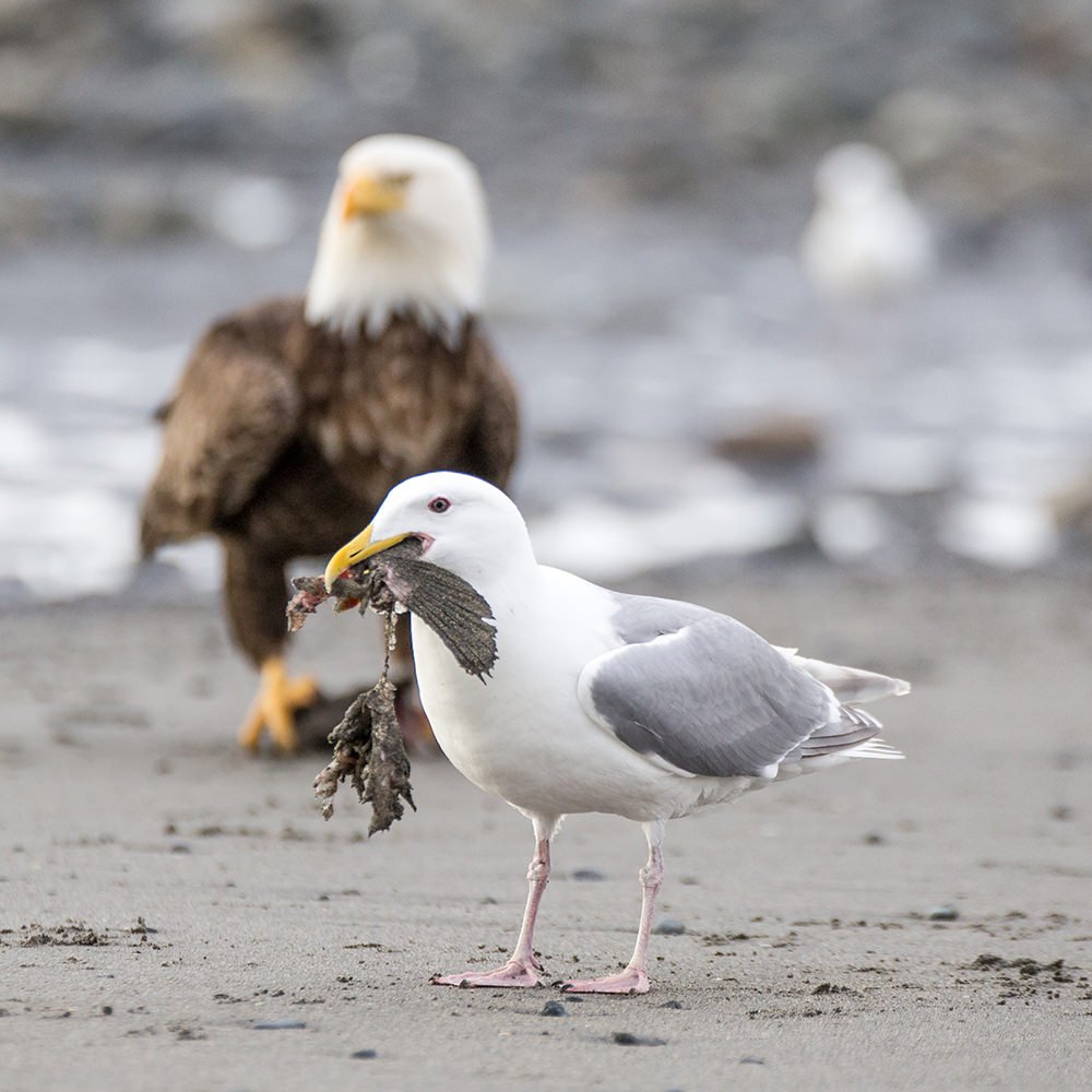
Lots and lots of Bald Eagles.

Eagle and seagull
Ah, yes, Bald Eagles

Which of course means lots and lots of Bald Eagle photos.

Before Emma filled too many memory cards with photos of eagles, we made the trip north, with a few days left before the impending arrival of our new roof top tent.


Trip stats

Miles driven: 87

Sticky buns eaten: 1, but it was freaking awesome

Bald eagles seen and photographed: 1 metric shit-tonne

Foods sampled:

Sticky bun: Big win. Temporary new favourite food until the next big thing.

Pizza: The USA knows how to make pizza. Sorry New Zealand, you have some catching up to do on that front.

Choc-Mint Ice-Cream gum: Minty fresh and tastes like dessert. Can’t go wrong here.


Recommendations for other travellers

Halibut campground This campground in Anchor Point is a few Miles from the hustle and bustle of Homer itself. There are also a conveniently large number of  Bald Eagles on the beach just at the edge of the campground. The cool sea breeze keeps the mosquitos at bay as well, so that is an extra bonus.

See also  Finally—Heading south like we're supposed to!

Two Sister’s Bakery for some sticky bun magic.

Homer Brewing Company is worth dropping in to sample a flight. If you are looking for a pint, we can both recommend the Red Knot Scottish although they brew a solid Oatmeal Stout as well.

The Pratt Museum  is a pretty fancy museum, we spent a while in here perusing all the exhibits. Although a lot of the content is very recent history, apparently many of the homesteaders who have donated articles to the exhibits are still all living in the area, so you could probably learn just as much by chatting to the right locals.

Alaska Islands and Oceans Visitor Centre is the place to go to learn more about the lengths people are going to conserve the natural resources in the area. Also, if you want to get a better grasp on how extreme the tides are in Kachemak Bay, the have a full-scale pole that shows the tide in real-time and highlights the extreme variation between the lowest and highest tides. (Although the tides in Kachemak Bay are not quite as dramatic as Turnagain arm, they are not by any means sissy namby-pamby tides)

If you arrive in Homer having not blown your budget, the walking trails over the other side of the bay sounded brilliant. But the cost of catching a boat put us off from finding out.

AlaskaartBald eaglebirdscampingeaglesgalleryhighwayHomerKenai Peninsulamuseumwestwildlife
Related Posts

Not quite Guatemala—Part 1

24th September 2016
0
0

There was one time, way back in Belize when we were very nearly in Guatemala.

Top notch security on the Guatemalan border. It sure keeps out those pesky tourists.

Location: El Pilar ruins, Belize. Distance to Guatemala: 615.18 m (2018.32 ft)

But ultimately we decided not to go, and returned to Mexico instead.

We then of course faffed about for quite some time in Mexico. So long in fact that many of the friends we thought we would see again in Guatemala were, by this time, in Costa Rica, Panama, and even South America. Whoops.

The rumour going around was that we were going to apply for Mexican citizenship. The thought did cross our minds. We love Mexico. But seriously. It was time to burn some rubber and leave Mexico in our dust. Sort of.

Maybe after a detour around the Mexico/Guatemala border.

From San Cristóbal, it would have been possible to drive directly to the La Mesilla border crossing and be in Guatemala the same day. It would have been a 175 km (108 mi) drive. We could have breakfasted in Mexico and enjoyed dinner in Guatemala.

Nope. Too easy.
Nope. Too easy.

Instead we opted for the smaller, quieter border crossing at El Ceibo. Which meant we might as well drive back through Palenque. The road between San Cristóbal and Palenque is famous for road blocks. But it sounded like the protesters would open the road each day in the mid afternoon if you waited patiently, so even with the delay, the 219 km (136 mi) journey to Palenque sounded pretty manageable.

Too straightforward.

Instead, we opted for an elaborate detour around the Mexico/Guatemala border with time to partake in some sightseeing en route. No rush… right?

Just right.
Just right.

Location: San Cristóbal de Las Casas. Distance to Guatemala: (as the crow flies) 121.58 km (75.54 mi)

IMG_9409

First stop, a rock arch in a nature reserve just out of San Cristóbal.

See also  Escape

Location: El Arcotete. Distance to Guatemala: 120.15 km (74.66 mi)

We don’t want to drive too far in one go, now do we?

Next up. A recreation park featuring some caves, just down the road.

Location: Rancho Nuevo caves. Distance to Guatemala: 112.62 km (69.98 mi)

Time to make some serious progress towards Guatemala… oh look—a waterfall!

Location: Cascadas El Chiflón. Distance to Guatemala: 56.76 km (35.27 mi)

img_9590

Now we’re seriously closing in on the border.

Location: Lagunas de Montebello. Distance to Guatemala: 3.82 km (2.38 mi)

The weather was a bit bleak when we first arrived at Lagunas de Montebello

If we camp really close to the border, does that count as visiting Guatemala?

Location: Lago Tziscao. Distance to Guatemala: 1.02 km (3,332 feet)

Either way it’s a great spot to watch sunrise.

img_9693-pano-edit

(You can see a larger panorama in more detail in our full screen panorama gallery)

Then there was that time we did go to Guatemala, but didn’t get our passports stamped.

Location: Lago internacional. Distance to Guatemala: 0km

From there we can only drive further from the border… or go back and get our passports stamped. We of course, drove further from the border.

At first, only a short distance to take a look at Lago Pojoj.

Location: Lago Pojoj. Distance to Guatemala: 3.19 km (1.98 mi)

You can see this panorama a bit larger in our gallery as well.

img_9751-pano

Then we drove a bit further away.

Location: Las Nubes. Distance to Guatemala: 13.86 km (8.61 mi)

Our favourite thing about this spot? The nice peaceful swimming hole located just at the top of this set of churning, crushing falls that eventually disappear into a rocky gorge and emerge hundreds of metres below in a valley. Way to make health and safety very much optional Mexico.

See also  Rocks, history and how not to navigate a colonial town

Anyway. Onward and… further again from Guatemala. We wanted to explore the jungle, but were too cheap to pay for the boat trip. So we looked at the captive Scarlet Macaws and played about on the grounds of the luxury eco hotel that we were equally to cheap to stay at.

Location: Las Guacamayas. Distance to Guatemala: 20.09 km (12.49 mi)

The next stop on our itinerary tiki-touring around the Mexico-Guatemala border was the mysterious Yaxchilan ruins.

But, since we took such a long detour on route to Guatemala, it is probably best if you read about that in our second instalment of ‘Not quite in Guatemala’. Stay tuned…

The most savage creature in Alaska

27th July 2014
4
0

But you’ve already written a post on bears!

Look closer, there is a bear in this photo, but it isn’t him that we are afraid of.

(more…)
See also  Mechanical woes and the road to Oaxaca
1 Comment
    Moose, marmots and bears, oh my! | Flightless Kiwis says: Reply
    July 31st 2014, 5:41 pm

    […] Oh and a few bald eagles. […]

Leave a Reply Cancel reply

Your email address will not be published. Required fields are marked *

Newsletter Signup

Categories

  • Australia
  • Beer
  • Belize
  • Bolivia
  • Budgeting
  • Canada
  • Central America
  • Cook Islands
  • Cuba
  • CVT tent
  • Digital Nomad
  • Ecuador
  • Featured
  • Gear Reviews
  • Guatemala
  • Hiking
  • Humour
  • Kaylee
  • Mexico
  • New Zealand
  • North America
  • Oxfam Trailwalker
  • Peru
  • Photo Friday
  • Planning
  • Smoke Chaser
  • South America
  • South East Asia
  • Statistics
  • Travel
  • Uncategorized
  • United States
  • Upgrades
  • Vehicle
  • Video
Trapped in bear countryby flightlesskiwi / June 30, 2014
Small town Alaskaby flightlesskiwi / July 4, 2014

Stay In Touch

Subscribe for the latest updates.

Instagram

© 2020 FlightlessKiwis . All rights reserved.

  • Home
  • About
  • Blog
  • Contact
  • Privacy

Recent Posts

  • On the road to ruin (s)
    by flightlesskiwi / 12th October 2015
  • Digital nomads
    by flightlesskiwi / 21st April 2015
  • Why we left too soon for the April Sun in Cuba
    by flightlesskiwi / 3rd September 2015

Looking four our old blog?

We’ve archived our stories and photos from our three year road trip from Deadhorse, Alaska, USA to Ushuaia, Tierra del Fuego Argentina here:

PANAM BLOG

Smoke Chaser logo
Flightless Kiwis logo