IPhone LogoIPad LogoLight Logo
  • Home
  • Blog
  • About
  • Contact
North America United States
by flightlesskiwi

The lowest point of our trip

1st January 2015
1
0
Share

All trips have their low points. This journey is no exception. 

Fortunately this particular low point is measured in altitude, not in how many hours we spent plotting to poison each other. 

We arrived in Death Valley after the worst of the summer heat… or at least we thought we had. It was still a cozy 118ºF (47.7ºC) when we posed for photos at the thermometer outside Furnace Creek visitor centre. It did tick over to 119ºF (48.3ºC) briefly before we left the car park, but I guess that has nothing on their record high of 134ºF (57ºC).

Death Valley is famous for being pretty cosy. This is due to the valley itself being below sea level, hemmed in with jagged mountain ranges. The dry climate in the valley means little vegetation to reflect the heat, instead the air on the valley floor heats up, remains trapped in the area by the mountain ranges and the increased pressure due to the low altitude. This air cycles around, getting increasingly hot and basically heating the area up like an oven.

Conveniently, as one of the drier places on the planet, we figured at least we didn’t have to worry about getting rained on, so we thought we might as well get out and enjoy the non-stop sunshine. After a rainy summer in Alaska and Canada, we had been enjoying the drier climate of Nevada and Eastern California.

When we dropped by the Furnace Creek Visitor centre, the ranger had mentioned that as it was pretty cozy and warm, he didn’t recommend walking far or camping at the valley floor. 

Death Valley Heat

Death Valley it turns out, has plenty of extreme landscapes to enjoy, most of which you don’t have to stray very far from the air-conditioned comfort of your vehicle to see… convenient! 

Death Valley National Park

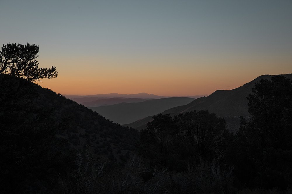
The first night we camped in Death Valley we headed to the highest camp spot in the park at Mahogany Flat (thanks Next Big Adventure for the tip!) and camping at 8200′ (2500m) we were bundling up to stay warm rather than sweltering on the valley floor.

View from Mahogany Flat

The other thing that Death Valley is famous for is clear night skies—perfect for stargazing. But this guy got in the way, so we took his photo instead:

Moon above Death Valley

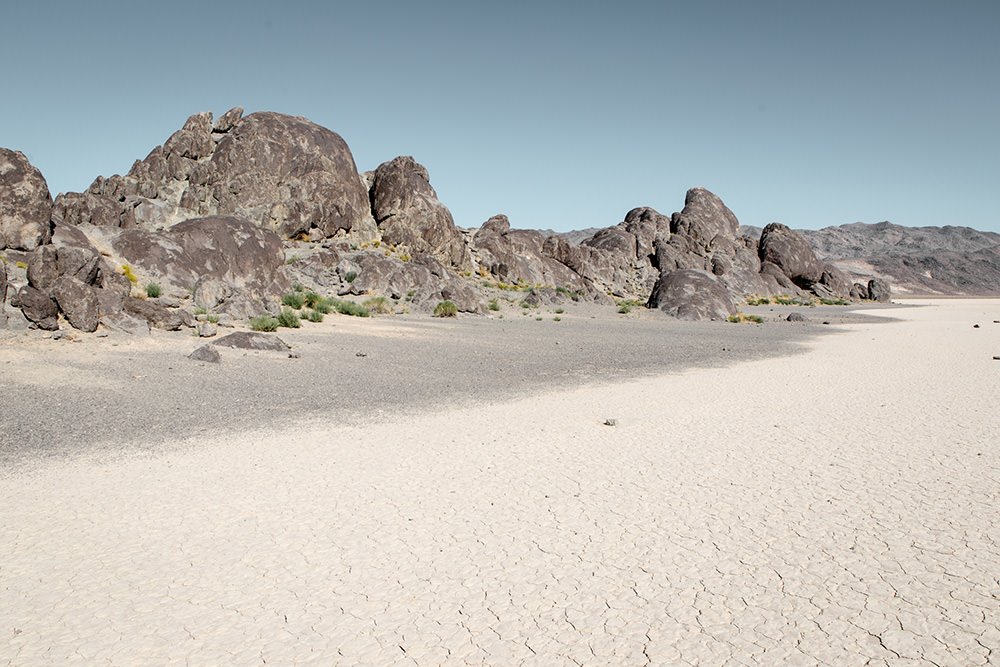
Not being able to resist a detour to view the mysterious moving rocks, we headed to the Racetrack Playa the next day. These rocks are famous for leaving trails in the surface of the dry lake bed where they sit, showing that they clearly move, but leaving scientists baffled for years. Recently they have figured out it is due to the break up and melting of very thin sheets of ice, moving the rocks with them as they shift. Which takes some of the mystery away, but it is still a pretty neat phenomena. 

See also  Canadian retail hospitality—it reminds us of home

We drove through a windy back road to get there. The road was marked clearly as ‘possibly impassable 4wd only’ on the map, but it turned out to be a pleasant drive.

Until we got to Teakettle Junction where it met the ‘main road’ out to the Playa. Welcome to the worlds most heavily washboarded road.

With the contents of our house on wheels rattling violently with every metre we crawled forward, whilst simultaneously our fillings were rattling out of our teeth, we knew it was going to be slow progress. 

But at the end magical moving rocks awaited, so we persevered while our home shuddered violently around us, pots and pans crashed together, tools bounced and the water container rolled exuberantly.

We eventually rolled to a halt at a spot about two-thirds of the way along the playa where we could see some rocks scattered about on the surface. We wandered out excitedly expecting to see rocks leaving big trails gouged beneath them in all directions.

We could see some trails, but they weren’t that clearly defined and certainly not worth the miles of washboarded road still remaining between us and our planned camp spot for the day. 

'Racetrack' rock

Dang it. *

We went to check out the ‘Grandstand’ on our way back out. A strange rocky outcrop in the middle of the flat dry lake bed.

The Grandstand, Racetrack Playa, Death Valley National Park

It wasn’t like the area wasn’t scenic. There just hadn’t been enough magical moving rocks to justify pulverising the contents of our home for so many miles.

We walked back to the car muttering things like ‘well at least the drive in was scenic’. When Ben spotted that the car was haemorrhaging fluid at an alarming rate. 

Fluid leaking from vehicle
Hmmm… where could that be coming from?

Uh oh.

It was about now that we remembered the other piece of advice that the ranger had given us. Don’t drive the back roads when it is hot—there’s no help out there.

See also  On the road to ruin (s)

Luckily, it turns out that the culprit was actually our spare water bottle that had burst open due to all the rough roads and was simply haemorrhaging precious H2O in one of the driest places on earth, several miles from civilisation. 

Just our water

Oh well, no worries then. It isn’t like we’re going to get thirsty here… right?

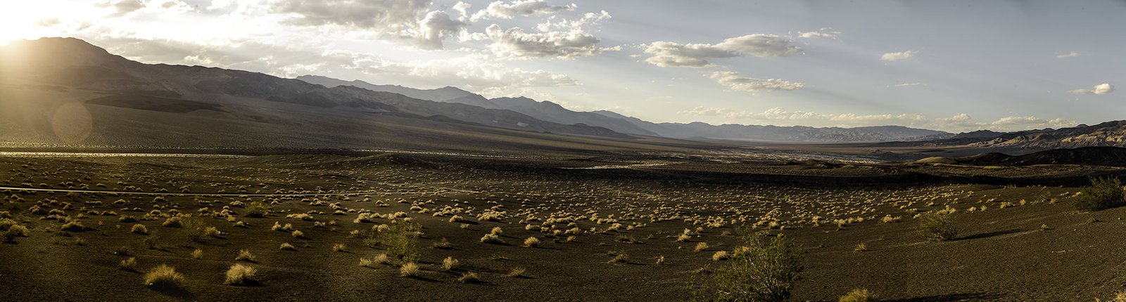
We battled the enraging washboards all the way back to the paved road. Stopping to enjoy some of Death Valley’s amazing scenery to keep our spirits up. 

Death Valley National Park

It was getting late and we made the call to camp at Mesquite Spring which was at 1800′ (450m) above sea level and therefore cooler than camping on the valley floor. At least that is what we thought.

We set up camp. Noted the clouds forming. Thought nothing more of it. Then the wind started to blow. 

Our camp was buffeted by gust after gust of superheated air from the valley floor. This kept the evening temperature in our camp spot at what one can only assume was the low 40ºs (over 100ºF). Toasty. I guess that’s why there were so few people camping there… oops. 

Finally in the early hours of the morning it cooled to a temperature where it was possible to sleep… then we awoke to the sound of rain. 

Rain in Death Valley

In the one of the driest places on earth? Really?

The rain had brought with it some chilly temperatures, so we bundled up in our winter woollies:

Brrrrr…
99ºF = 37.2ºC, Actually did feel quite relievingly cool.

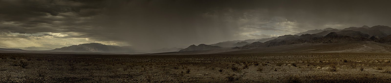
Followed by a sightseeing tour of Death Valley in the rain:

Rain in Death Valley National Park

The skies cleared for the absolute lowest point of our trip:

Lowest point of the trip

Badwater basin is 85m below sea level according to the sign.

Javier at the lowest point of the trip

But Javier (our GPS) reckoned it was closer to -88m. 

No matter who you ask, we suspect that this will be the lowest point of the trip.

Until we really do decide to poison each other. 

* It turns out, we have been told, that if we had driven right to the very far end, not just 2/3 of the way along, that was where all the good rocks were. Live and learn. Probably can’t be bothered going back just yet…

abandonedCaliforniacampingDeath Valleydesertdrydustghost townhotmoonmysteryNational ParkplayarocksUSA
Related Posts

The best places to lose your money in Las Vegas

29th December 2014
5
0

From one strange town that appeared from the dust of the Nevada desert to another. Las Vegas seemed like the obvious next stop after a week at Burning Man.

At a glance they might seem similar. Both springing up out of an otherwise barren desert. Both full of bright lights and constant action, events and people, always something happening.

But in reality they are two polar opposites.

(more…)
See also  Let there be LED light!

Not quite Guatemala—Part 1

24th September 2016
0
0

There was one time, way back in Belize when we were very nearly in Guatemala.

Top notch security on the Guatemalan border. It sure keeps out those pesky tourists.

Location: El Pilar ruins, Belize. Distance to Guatemala: 615.18 m (2018.32 ft)

But ultimately we decided not to go, and returned to Mexico instead.

We then of course faffed about for quite some time in Mexico. So long in fact that many of the friends we thought we would see again in Guatemala were, by this time, in Costa Rica, Panama, and even South America. Whoops.

The rumour going around was that we were going to apply for Mexican citizenship. The thought did cross our minds. We love Mexico. But seriously. It was time to burn some rubber and leave Mexico in our dust. Sort of.

Maybe after a detour around the Mexico/Guatemala border.

From San Cristóbal, it would have been possible to drive directly to the La Mesilla border crossing and be in Guatemala the same day. It would have been a 175 km (108 mi) drive. We could have breakfasted in Mexico and enjoyed dinner in Guatemala.

Nope. Too easy.
Nope. Too easy.

Instead we opted for the smaller, quieter border crossing at El Ceibo. Which meant we might as well drive back through Palenque. The road between San Cristóbal and Palenque is famous for road blocks. But it sounded like the protesters would open the road each day in the mid afternoon if you waited patiently, so even with the delay, the 219 km (136 mi) journey to Palenque sounded pretty manageable.

Too straightforward.

Instead, we opted for an elaborate detour around the Mexico/Guatemala border with time to partake in some sightseeing en route. No rush… right?

Just right.
Just right.

Location: San Cristóbal de Las Casas. Distance to Guatemala: (as the crow flies) 121.58 km (75.54 mi)

IMG_9409

First stop, a rock arch in a nature reserve just out of San Cristóbal.

See also  Colorado is closed. Part 1.

Location: El Arcotete. Distance to Guatemala: 120.15 km (74.66 mi)

We don’t want to drive too far in one go, now do we?

Next up. A recreation park featuring some caves, just down the road.

Location: Rancho Nuevo caves. Distance to Guatemala: 112.62 km (69.98 mi)

Time to make some serious progress towards Guatemala… oh look—a waterfall!

Location: Cascadas El Chiflón. Distance to Guatemala: 56.76 km (35.27 mi)

img_9590

Now we’re seriously closing in on the border.

Location: Lagunas de Montebello. Distance to Guatemala: 3.82 km (2.38 mi)

The weather was a bit bleak when we first arrived at Lagunas de Montebello

If we camp really close to the border, does that count as visiting Guatemala?

Location: Lago Tziscao. Distance to Guatemala: 1.02 km (3,332 feet)

Either way it’s a great spot to watch sunrise.

img_9693-pano-edit

(You can see a larger panorama in more detail in our full screen panorama gallery)

Then there was that time we did go to Guatemala, but didn’t get our passports stamped.

Location: Lago internacional. Distance to Guatemala: 0km

From there we can only drive further from the border… or go back and get our passports stamped. We of course, drove further from the border.

At first, only a short distance to take a look at Lago Pojoj.

Location: Lago Pojoj. Distance to Guatemala: 3.19 km (1.98 mi)

You can see this panorama a bit larger in our gallery as well.

img_9751-pano

Then we drove a bit further away.

Location: Las Nubes. Distance to Guatemala: 13.86 km (8.61 mi)

Our favourite thing about this spot? The nice peaceful swimming hole located just at the top of this set of churning, crushing falls that eventually disappear into a rocky gorge and emerge hundreds of metres below in a valley. Way to make health and safety very much optional Mexico.

See also  The amazing, convenient glaciers of Alaska

Anyway. Onward and… further again from Guatemala. We wanted to explore the jungle, but were too cheap to pay for the boat trip. So we looked at the captive Scarlet Macaws and played about on the grounds of the luxury eco hotel that we were equally to cheap to stay at.

Location: Las Guacamayas. Distance to Guatemala: 20.09 km (12.49 mi)

The next stop on our itinerary tiki-touring around the Mexico-Guatemala border was the mysterious Yaxchilan ruins.

But, since we took such a long detour on route to Guatemala, it is probably best if you read about that in our second instalment of ‘Not quite in Guatemala’. Stay tuned…

1 Comment
    Coleman 2 Burner Dual Fuel Compact Liquid Fuel Stove | Gear Review | Flightless Kiwis says: Reply
    April 7th 2015, 7:19 am

    […] we have owned it. In that time it has faced rain, snow, freezing conditions, the baking heat of Death Valley, dust and salty ocean air. None of these challenges seem to have had an adverse affect on the […]

Leave a Reply Cancel reply

Your email address will not be published. Required fields are marked *

Newsletter Signup

Categories

  • Australia
  • Beer
  • Belize
  • Bolivia
  • Budgeting
  • Canada
  • Central America
  • Cook Islands
  • Cuba
  • CVT tent
  • Digital Nomad
  • Ecuador
  • Featured
  • Gear Reviews
  • Guatemala
  • Hiking
  • Humour
  • Kaylee
  • Mexico
  • New Zealand
  • North America
  • Oxfam Trailwalker
  • Peru
  • Photo Friday
  • Planning
  • Smoke Chaser
  • South America
  • South East Asia
  • Statistics
  • Travel
  • Uncategorized
  • United States
  • Upgrades
  • Vehicle
  • Video
Thanks from the Flightless Kiwisby flightlesskiwi / December 31, 2014
The truth is out thereby flightlesskiwi / January 4, 2015

Stay In Touch

Subscribe for the latest updates.

Instagram

© 2020 FlightlessKiwis . All rights reserved.

  • Home
  • About
  • Blog
  • Contact
  • Privacy

Recent Posts

  • On the road to ruin (s)
    by flightlesskiwi / 12th October 2015
  • Digital nomads
    by flightlesskiwi / 21st April 2015
  • Why we left too soon for the April Sun in Cuba
    by flightlesskiwi / 3rd September 2015

Looking four our old blog?

We’ve archived our stories and photos from our three year road trip from Deadhorse, Alaska, USA to Ushuaia, Tierra del Fuego Argentina here:

PANAM BLOG

Smoke Chaser logo
Flightless Kiwis logo